Forest dynamics where typhoon winds blow
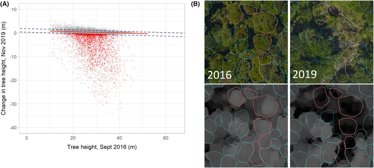
Tropical cyclones (TCs) sporadically cause extensive damage to forests. However, little is known about how TCs affect forest dynamics in mountainous terrain, due to difficulties in modelling wind flows and quantifying structural changes. Typhoon Mangkhut (2018) was the strongest TC to strike Hong Kong in over 40 yr, with gusts > 250 km h−1. Remarkably, the event was captured…
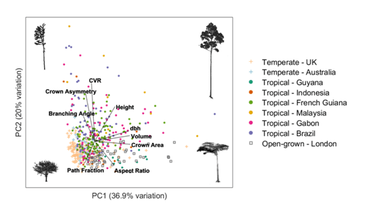
Wind Shapes the Growth Strategies of Trees in a Tropical Forest
In tropical forests, trees strategically balance growth patterns to optimise fitness amid multiple environmental stressors. Wind poses the primary risk to a tree’s mechanical stability, prompting developments such as thicker trunks to withstand the bending forces. Therefore, a trade-off in resource allocation exists between diameter growth and vertical growth to compete for light. We explore…
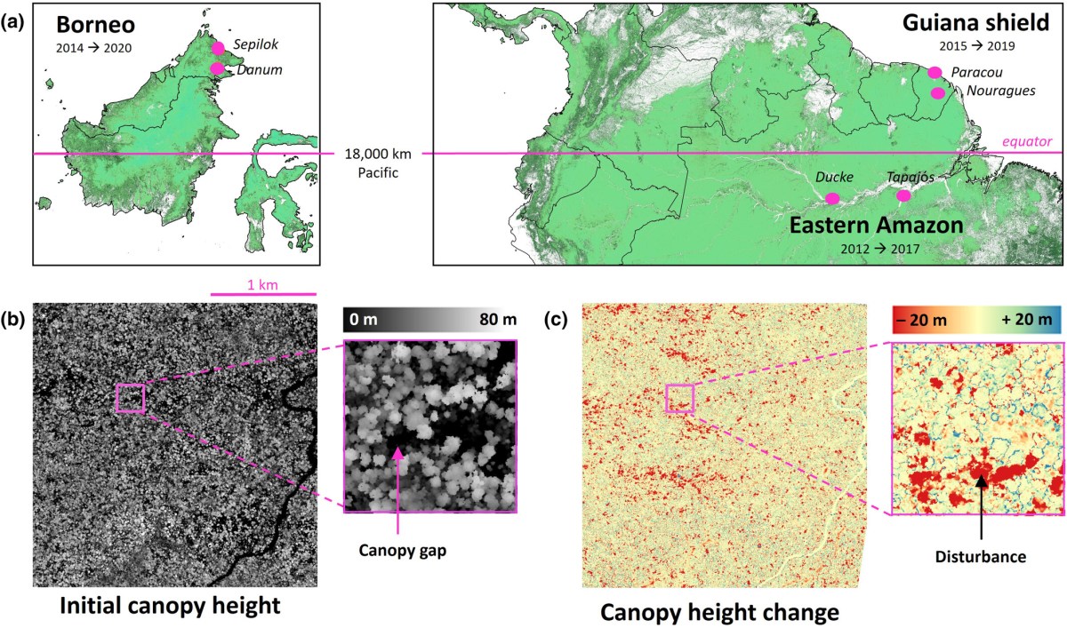
Tall Bornean forests experience higher canopy disturbance rates than those in the eastern Amazon or Guiana shield
The future of tropical forests hinges on the balance between disturbance rates, which are expected to increase with climate change, and tree growth. Whereas tree growth is a slow process, disturbance events occur sporadically and tend to be short-lived. This difference challenges forest monitoring to achieve sufficient resolution to capture tree growth, while covering the…
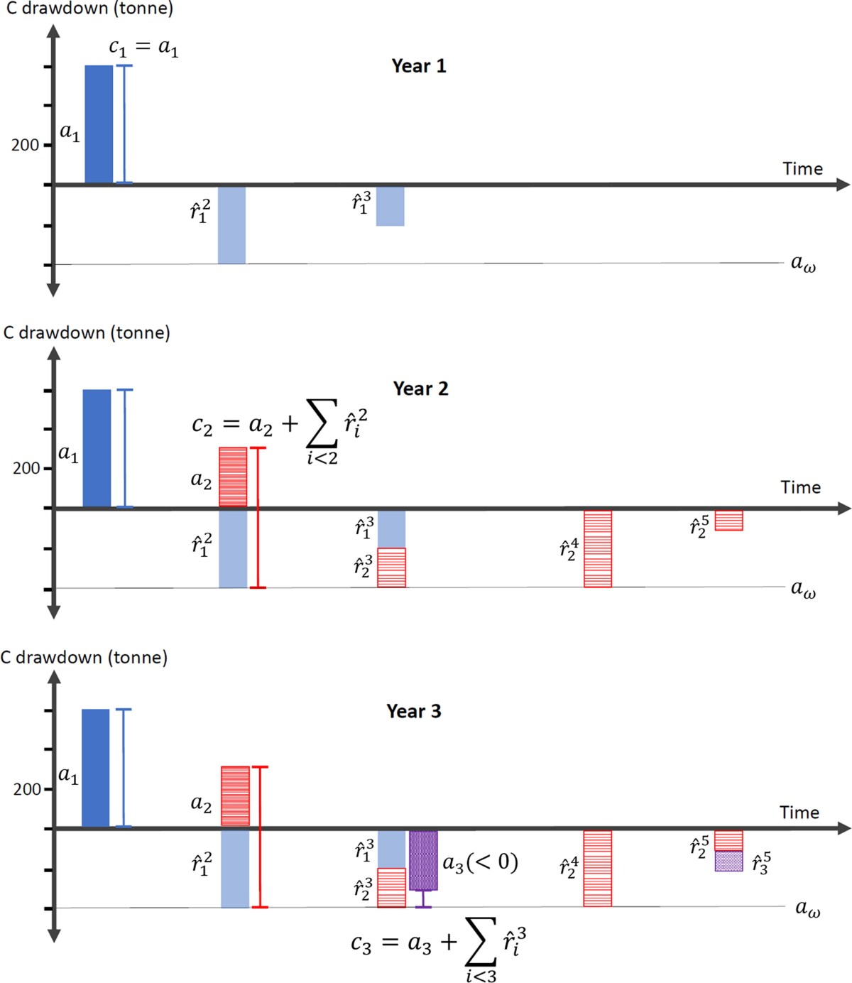
Mitigating risk of credit reversal in nature-based climate solutions by optimally anticipating carbon release
Nature-based climate solutions supply carbon credits generated from net carbon drawdown in exchange for project funding, but their credibility is challenged by the inherent variability and impermanence of drawdown. By evaluating drawdown benefits from a social cost of carbon perspective, project developers can enhance credibility and estimate impermanence by conservatively anticipating drawdowns to be eventually…
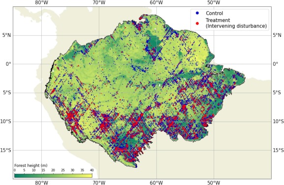
Repeat GEDI footprints measure the effects of tropical forest disturbances
More of the Amazon rainforest is disturbed each year than completely deforested, but the impact of these disturbances on the carbon cycle remains poorly understood. Recent algorithmic advances using optical and radar remote sensing have improved detection of disturbances at fine spatiotemporal resolution, but quantifying changes in forest structure and biomass associated with these detected disturbances has proven challenging. The Global…
Consistent patterns of common species across tropical tree communities
Trees structure the Earth’s most biodiverse ecosystem, tropical forests. The vast number of tree species presents a formidable challenge to understanding these forests, including their response to environmental change, as very little is known about most tropical tree species. A focus on the common species may circumvent this challenge. Here we investigate abundance patterns of…
Computational tools for assessing forest recovery with GEDI shots and forest change maps
Tropical secondary forests are ecosystems of critical importance for protecting biodiversity, buffering primary forest loss, and sequestering atmospheric carbon. Monitoring growth and carbon sequestration in secondary forests is difficult, with inventory plots sampling of secondary forests. The Global Ecosystem Dynamics Investigation (GEDI), a space-borne LiDAR sampler, provides billions of aboveground carbon density (ACD) estimates across the…
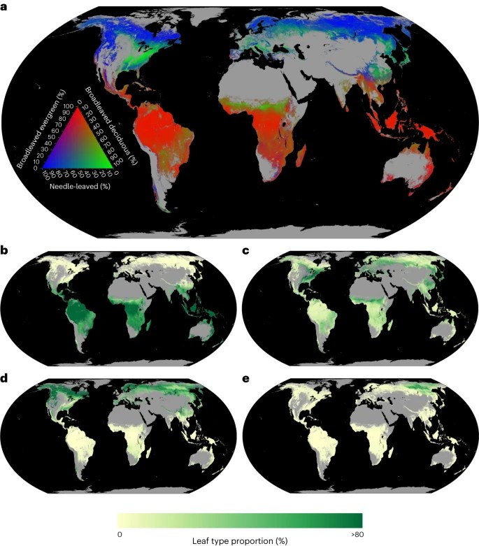
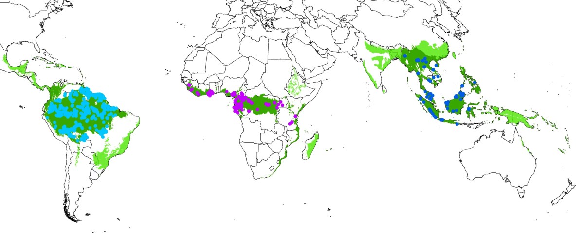
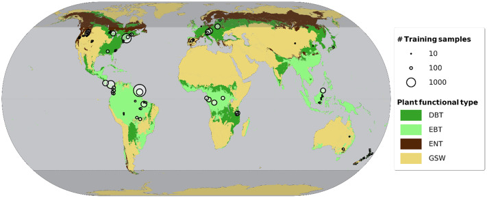
The global biogeography of tree leaf form and habit
Understanding what controls global leaf type variation in trees is crucial for comprehending their role in terrestrial ecosystems, including carbon, water and nutrient dynamics. Yet our understanding of the factors influencing forest leaf types remains incomplete, leaving us uncertain about the global proportions of needle-leaved, broadleaved, evergreen and deciduous trees. To address these gaps, we…
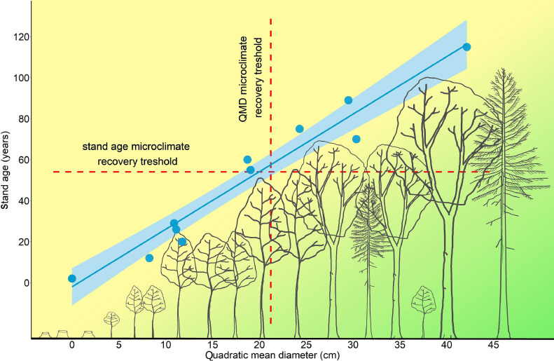
Microclimate variation and recovery time in managed and old-growth temperate forests
Microclimate is a key driver of forest dynamics and shapes the response of forest organisms to global warming. The spatial and temporal variability of microclimate is strongly affected by forest management, so it is important to know how microclimate varies along successional gradients of managed forests, and how microclimatic dynamics in managed forests differ from…
Accurate delineation of individual tree crowns in tropical forests from aerial RGB imagery using Mask R-CNN
Tropical forests are a major component of the global carbon cycle and home to two-thirds of terrestrial species. Upper-canopy trees store the majority of forest carbon and can be vulnerable to drought events and storms. Monitoring their growth and mortality is essential to understanding forest resilience to climate change, but in the context of forest…
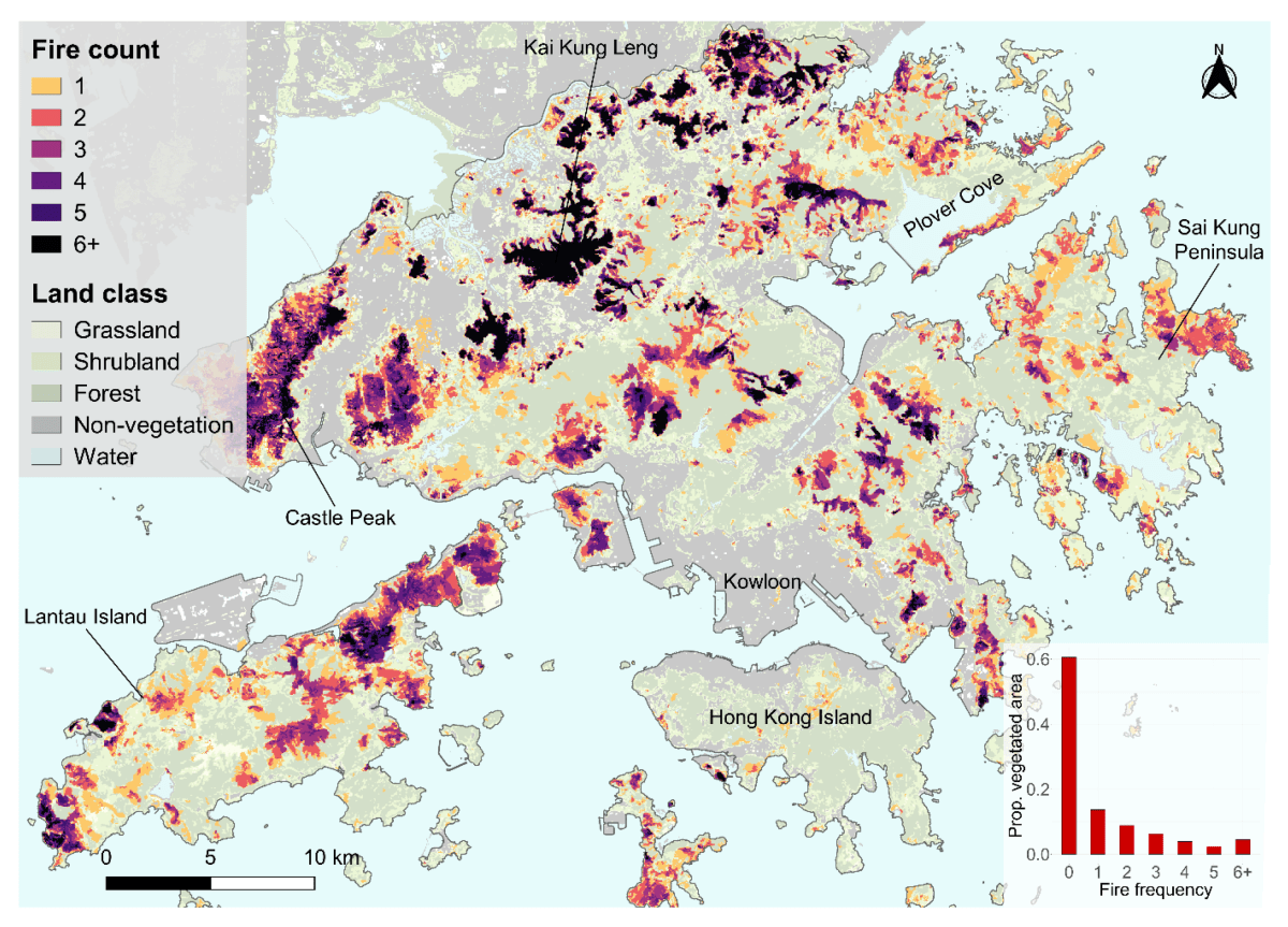
Reconstructing 34 Years of Fire History in the Wet, Subtropical Vegetation of Hong Kong Using Landsat
Burn-area products from remote sensing provide the backbone for research in fire ecology, management, and modelling. Landsat imagery could be used to create an accurate burn-area map time series at ecologically relevant spatial resolutions. However, the low temporal resolution of Landsat has limited its development in wet tropical and subtropical regions due to high cloud…
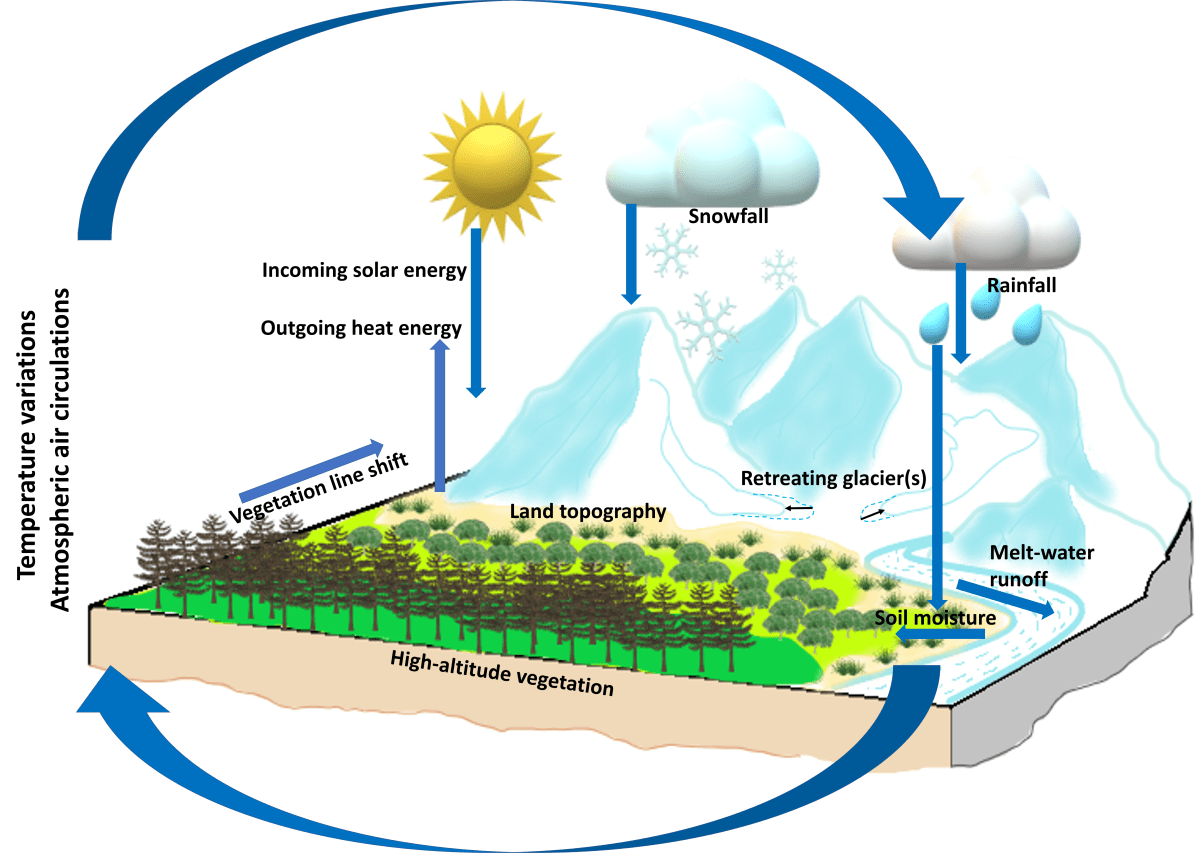
The rapid vegetation line shift in response to glacial dynamics and climate variability in Himalaya between 2000 and 2014
Climate change is causing glaciers to retreat across much of the Himalaya, leading to a rapid shift of the vegetation cover to higher altitudes. However, the rate of vegetation shift with respect to glacier retreat, climate change, and topographic parameters is not empirically quantified. Using remote sensing measurements, we estimate (a) the rate of glacier-ice…
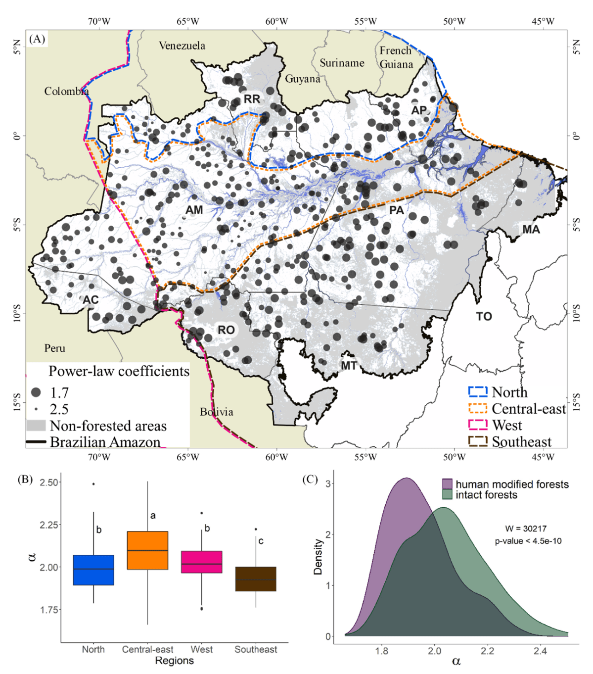
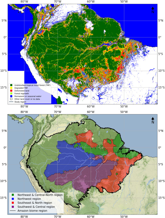
Forest disturbance and growth processes are reflected in the geographic distribution of large canopy gaps across the Brazilian Amazon
Canopy gaps are openings in the forest canopy resulting from branch fall and tree mortality events. The geographical distribution of large canopy gaps may reflect underlying variation in mortality and growth processes. However, a lack of data at the appropriate scale has limited our ability to study this relationship until now. We detected canopy gaps…
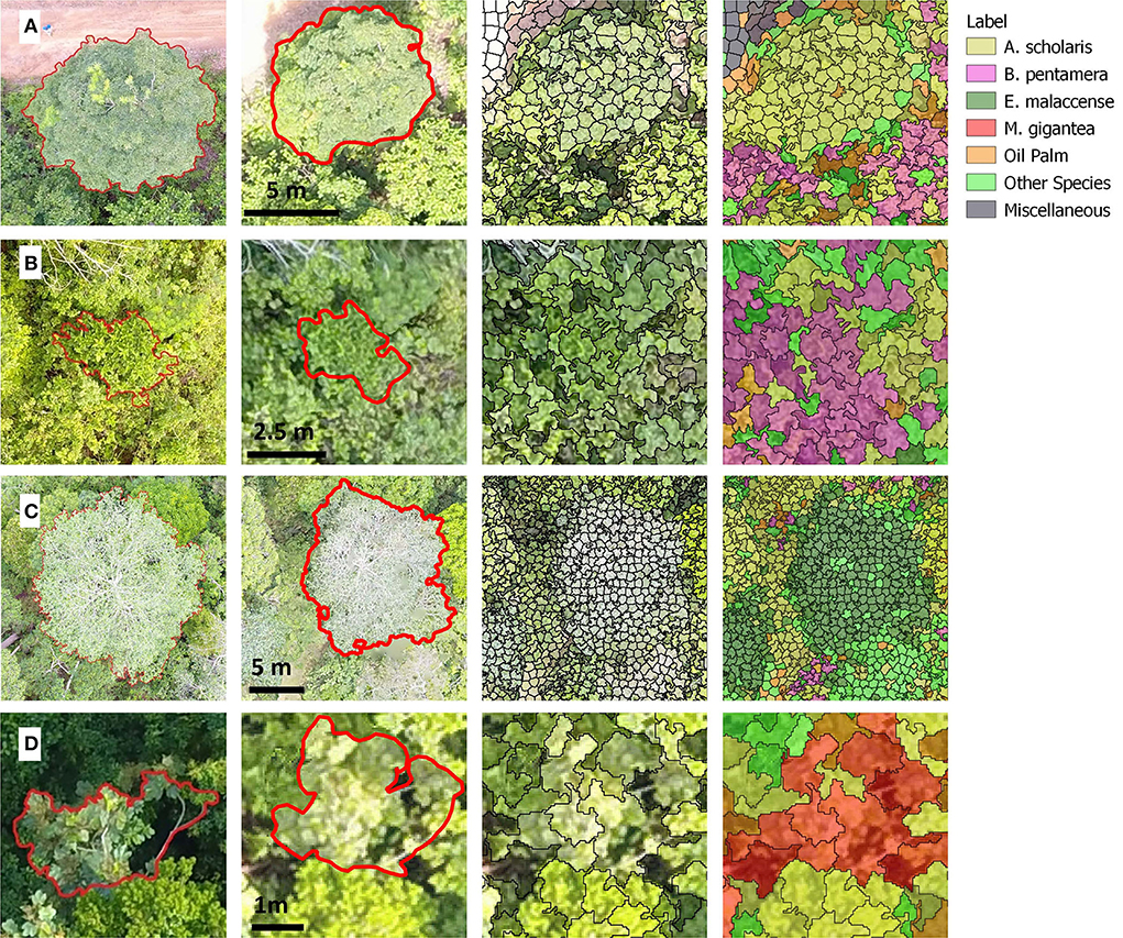
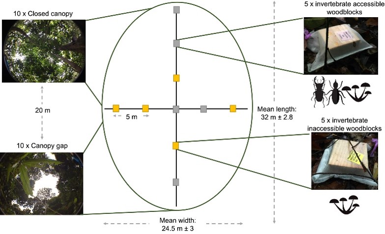
Monitoring early-successional trees for tropical forest restoration using low-cost UAV-based species classification
Logged forests cover four million square kilometres of the tropics, capturing carbon more rapidly than temperate forests and harbouring rich biodiversity. Restoring these forests is essential to help avoid the worst impacts of climate change. Yet monitoring tropical forest recovery is challenging. We track the abundance of early-successional species in a forest restoration concession in…

Using deep convolutional neural networks to forecast spatial patterns of Amazonian deforestation
Tropical forests are subject to diverse deforestation pressures while their conservation is essential to achieve global climate goals. Predicting the location of deforestation is challenging due to the complexity of the natural and human systems involved but accurate and timely forecasts could enable effective planning and on-the-ground enforcement practices to curb deforestation rates. New computer…
A global evaluation of the effectiveness of voluntary REDD+ projects at reducing deforestation and degradation in the moist tropics
Reducing Emissions from Deforestation and forest Degradation (REDD+) projects aim to contribute to climate change mitigation by protecting and enhancing carbon stocks in tropical forests, but there are no systematic global evaluations of their impact. Using a new data set for tropical humid forests, we used a standardised evaluation approach to quantify the performance of…
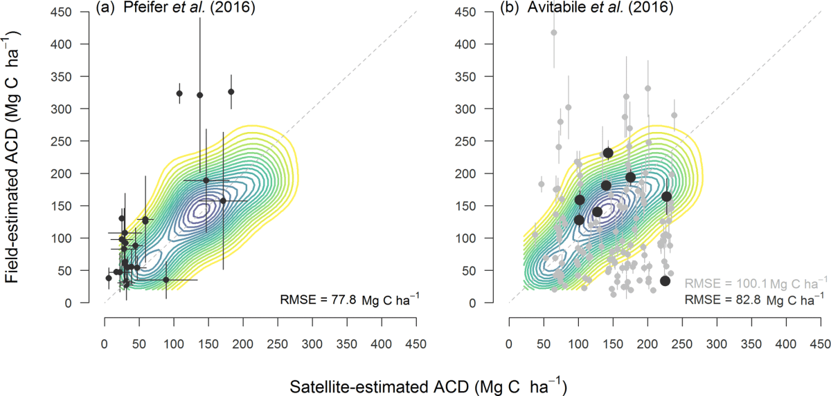
Aboveground biomass density models for NASA’s Global Ecosystem Dynamics Investigation (GEDI) lidar mission
NASA’s Global Ecosystem Dynamics Investigation (GEDI) is collecting spaceborne full waveform lidar data with a primary science goal of producing accurate estimates of forest aboveground biomass density (AGBD). This paper presents the development of the models used to create GEDI’s footprint-level (~25 m) AGBD (GEDI04_A) product, including a description of the datasets used and the procedure for final model…
Predicting leaf traits of temperate broadleaf deciduous trees from hyperspectral reflectance: can a general model be applied across a growing season?
Field spectroscopy is a powerful tool for monitoring leaf functional traits in situ, but it remains unclear whether universal statistical models can be developed to predict traits from spectral information, or whether re-calibration is necessary as conditions vary. In particular, multiple leaf traits vary simultaneously across growing seasons, and it is an open question whether…
Individual tree detection and crown segmentation based on metabolic theory from airborne laser scanning data
Laser scanning technology has enabled to study three-dimensional (3D) structures in forests. For example, airborne laser scanning (ALS) point cloud has been applied to detect individual trees and segment tree crowns. However, the accuracy of such approach remains a challenge because of the intersected crowns and complicated understories. We developed a metabolic theory-based algorithm for…
The motion of trees in the wind: a data synthesis
We have all seen trees swaying in the wind, but did you know that tree motion can teach us about ecology? Researchers have monitored tree motion for different purposes, from assessing wind damage risk to monitoring drought stress. Our new paper brings all this data together to study the differences between types of trees and test whether previous results generalize across a range of data sets. We computed a set of descriptive features from the…
Taking the pulse of Earth’s tropical forests using networks of highly distributed plots
Tropical forests are the most diverse and productive ecosystems on Earth. While better understanding of these forests is critical for our collective future, until quite recently efforts to measure and monitor them have been largely disconnected. Networking is essential to discover the answers to questions that transcend borders and the horizons of funding agencies. Here…
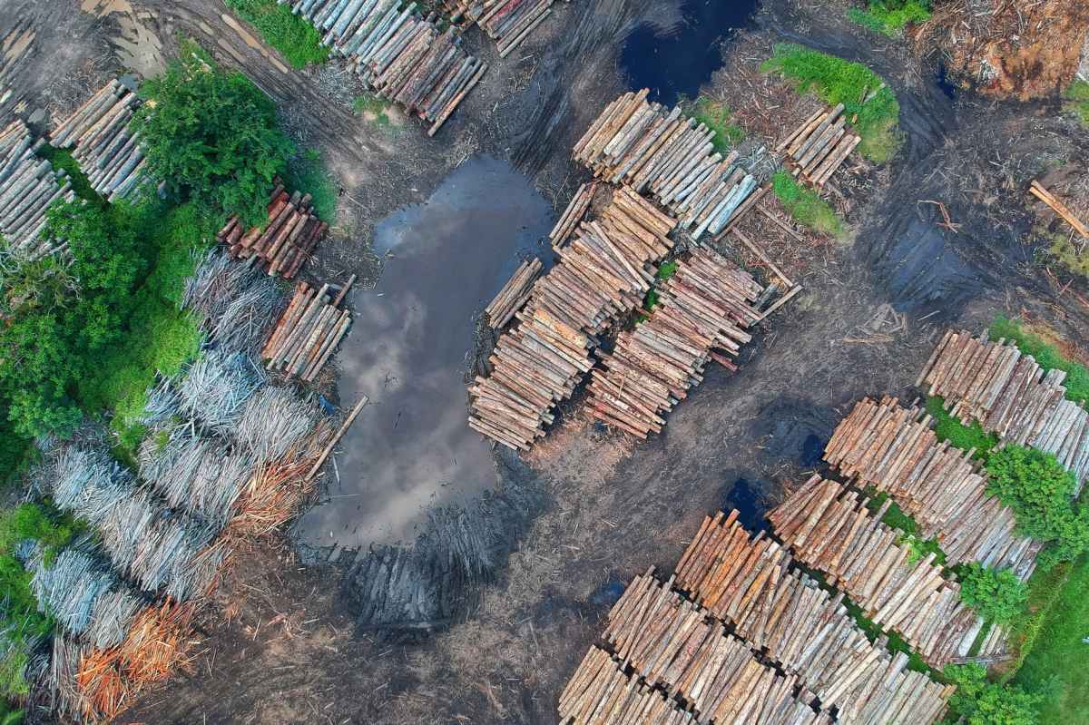
The impact of logging on vertical canopy structure across a gradient of tropical forest degradation intensity in Borneo
Forest degradation through logging is pervasive throughout the world’s tropical forests, leading to changes in the three-dimensional canopy structure that have profound consequences for wildlife, microclimate and ecosystem functioning. Quantifying these structural changes is fundamental to understanding the impact of degradation, but is challenging in dense, structurally complex forest canopies. We exploited discrete-return airborne LiDAR…
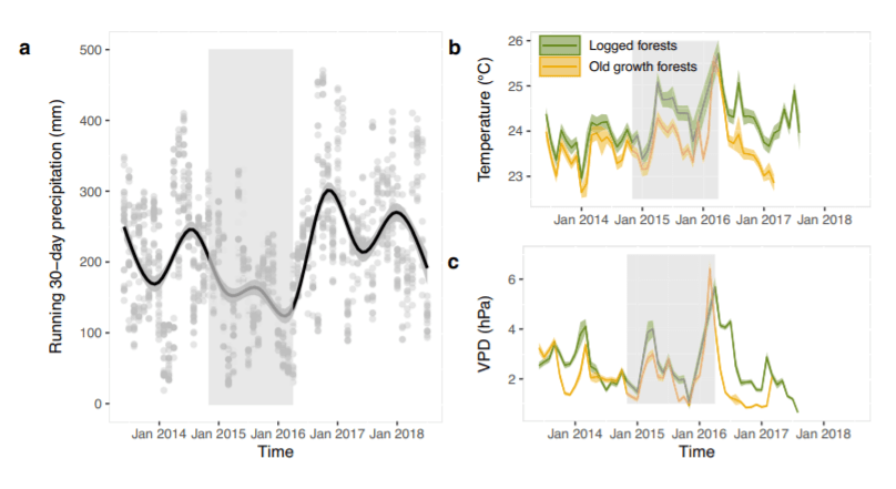
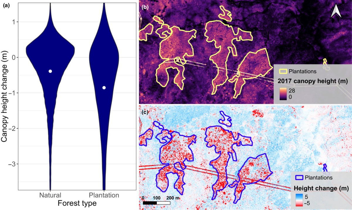
Recovery of logged forest fragments in a human-modified tropical landscape during the 2015-16 El Niño
It is unclear whether tropical forest fragments within plantation landscapes are resilient to drought. Here the authors analyse LiDAR and ground-based data from the 2015-16 El Niño event across a logging intensity gradient in Borneo. Although regenerating forests continued to grow, canopy height near oil palm plantations decreased, and a strong edge effect extended up…
Carbon flux and forest dynamics: Increased deadwood decomposition in tropical rainforest tree‐fall canopy gaps
Tree mortality rates are increasing within tropical rainforests as a result of global environmental change. When trees die, gaps are created in forest canopies and carbon is transferred from the living to deadwood pools. However, little is known about the effect of tree‐fall canopy gaps on the activity of decomposer communities and the rate of…
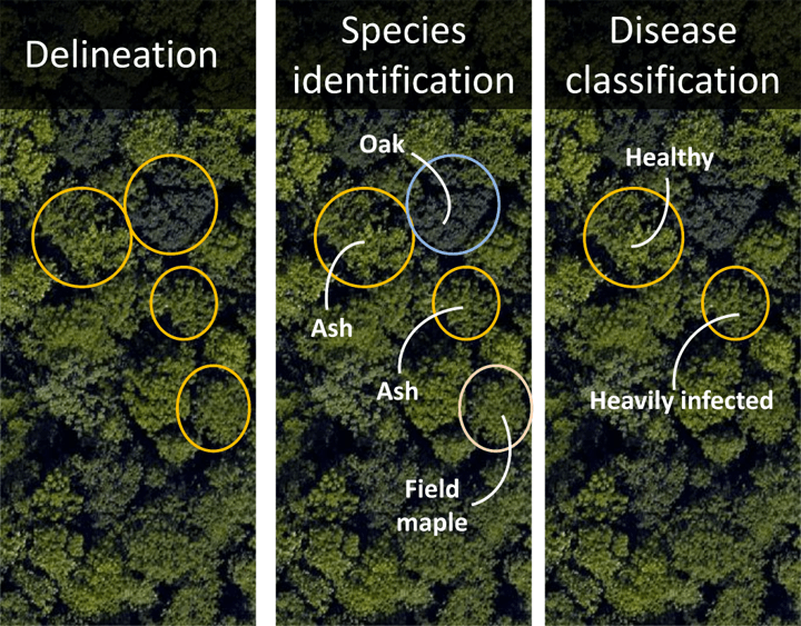
Monitoring ash dieback in British forests using hyperspectral remote sensing
Fungal ash dieback (Hymenoscyphus fraxineus) is posing an imminent threat to forest health in Europe. Using airborne hyperspectral imagery trained against 422 tree crowns of known species and ash dieback severity, we built PLS-DA and RF models that classified individual tree crowns (ITCs) into five species (>90% OA) and ash crowns into three disease severity…

Riparian buffers act as microclimatic refugia in oil palm landscapes
There is growing interest in the ecological value of set‐aside habitats around rivers in tropical agriculture. These riparian buffers typically comprise forest or other non‐production habitat, and are established to maintain water quality and hydrological processes, while also supporting biodiversity, ecosystem function and landscape connectivity. We investigated the capacity for riparian buffers to act as…
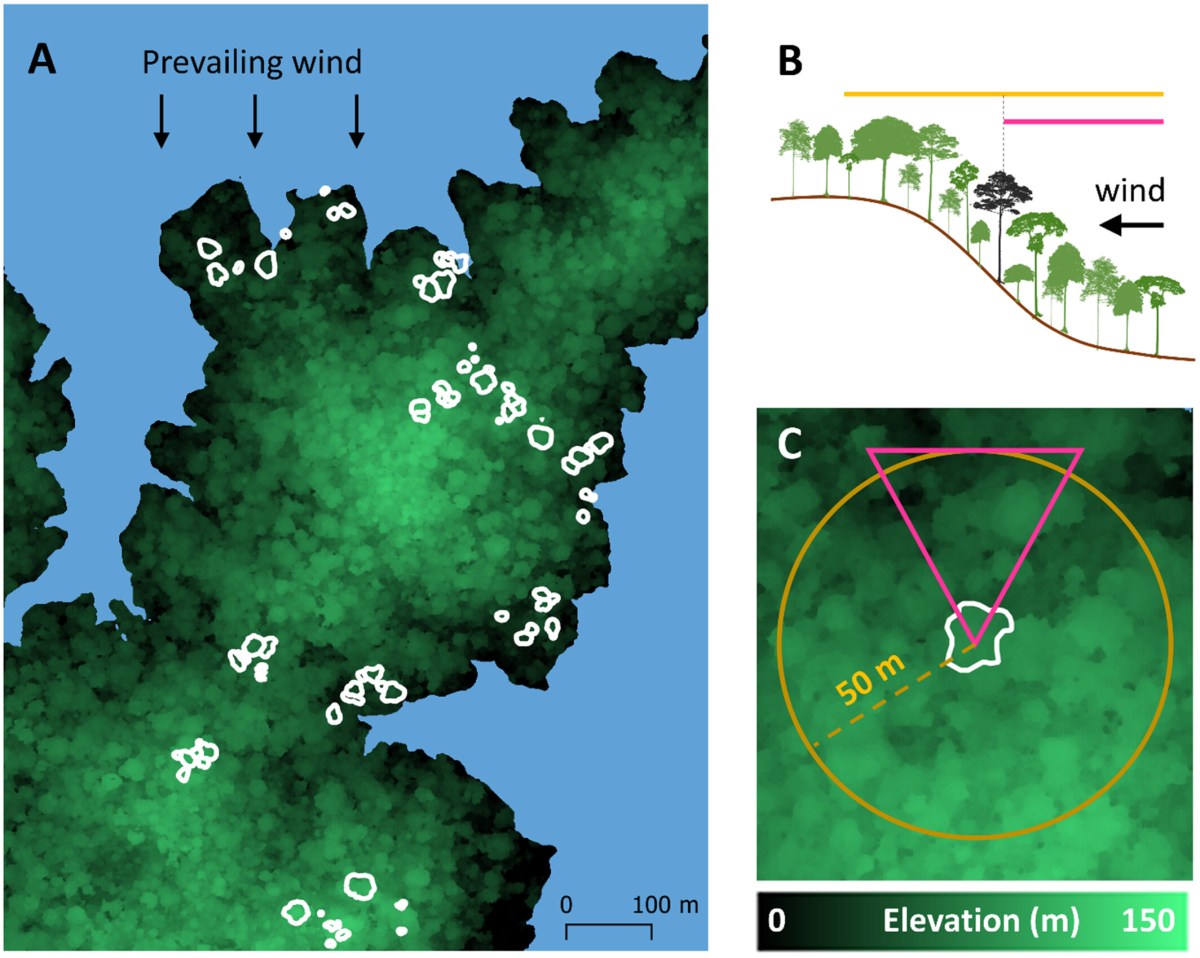
Do tall trees have a higher risk of wind damage?
When an intense tropical storm passes over a forest it leaves destruction in its wake. Post-damage surveys often show that the tall trees are disproportionately killed in these events. However, it is very difficult to attribute the cause of death of a large tree after the event. A tree may be snapped and lying on…

Resilience of Spanish forests to recent droughts and climate change
Time-series of canopy greenness derived from satellite imagery can beanalysed alongside environmental factors, species composition andmanagement regimes, to better understand forest resilience to drought.In Spain, forests are on average greening despite drying trends. Thisresilience manifests in the short-term with native species activatingdrought tolerance and avoidance mechanisms observable from space (i.e.losing and gaining little greenness like…

Treetops protect forest life from global warming
The forest canopy mitigates peak summer temperatures for the understorey. When that shade disappears, the organisms living there suffer. The cooling leaf canopy protects forest organisms from extreme temperatures and has a significant influence on their adaptation to global warming, according to this study which was published in the journal Science. The climate in the…

Standardizing Ecosystem Morphological Traits from 3D Information Sources
3D-imaging technologies provide measurements of terrestrial and aquatic ecosystems’ structure, key for biodiversity studies. However, the practical use of these observations globally faces practical challenges. First, available 3D data are geographically biased, with significant gaps in the tropics. Second, no data source provides, by itself, global coverage at a suitable temporal recurrence. Thus, global monitoring…
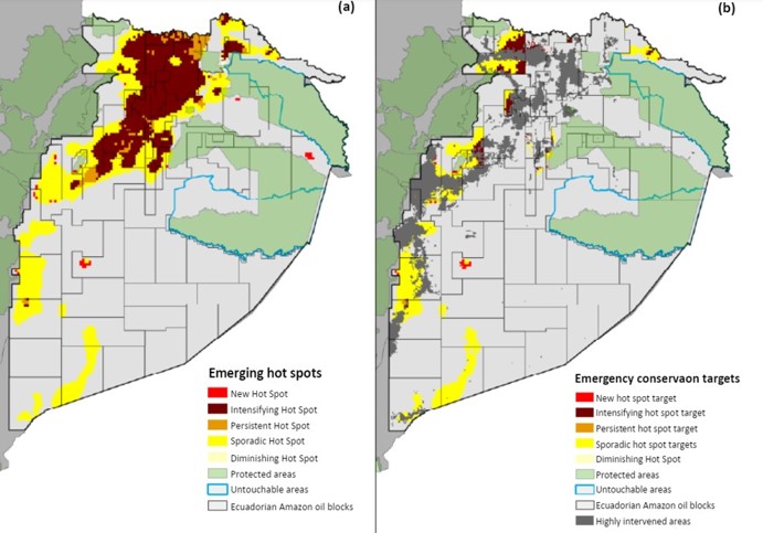
Protecting biodiversity and economic returns in resource‐rich tropical forests
In pursuit of socioeconomic development, many countries are expanding oil and mineral extraction into tropical forests. These activities seed access to remote, biologically rich areas, thereby endangering global biodiversity. Here we demonstrate that conservation solutions that effectively balance the protection of biodiversity and economic revenues are possible in biologically valuable regions. Using spatial data on…
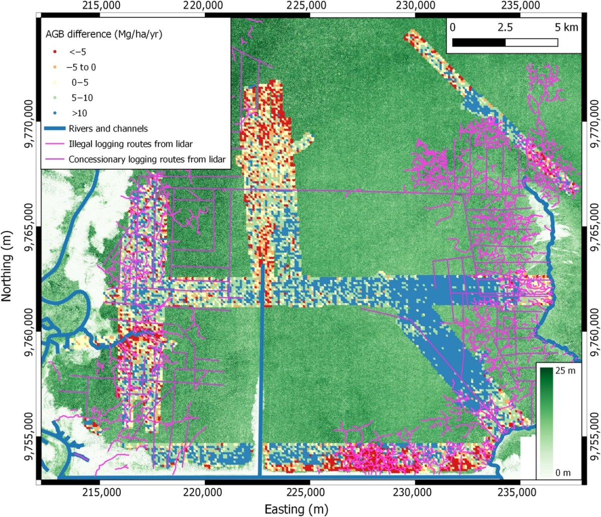
Dynamics of a human‐modified tropical peat swamp forest revealed by repeat lidar surveys
Tropical peat swamp forests (PSFs) are globally important carbon stores under threat. In Southeast Asia, 35% of peatlands had been drained and converted to plantations by 2010, and much of the remaining forest had been logged, contributing significantly to global carbon emissions. Yet, tropical forests have the capacity to regain biomass quickly and forests on…

Partial river flow recovery with forest age is rare in the decades following establishment
River flow responses to forestation at annual time scales The landscapes of the future might look very different to those today, and many have argued that increasing tree cover is essential to mitigate the worst effects of climate change. But forests affect many naturalprocesses, including water availability. We systematically reviewed the literature to determine how…
A Research Agenda for Microclimate Ecology in Human-Modified Tropical Forests
Logging and habitat fragmentation impact tropical forest ecosystems in numerous ways, perhaps the most striking of which is by altering the temperature, humidity, and light environment of the forest—its microclimate. Because local-scale microclimatic conditions directly influence the physiology, demography and behavior of most species, many of the impacts of land-use intensification on the biodiversity and…
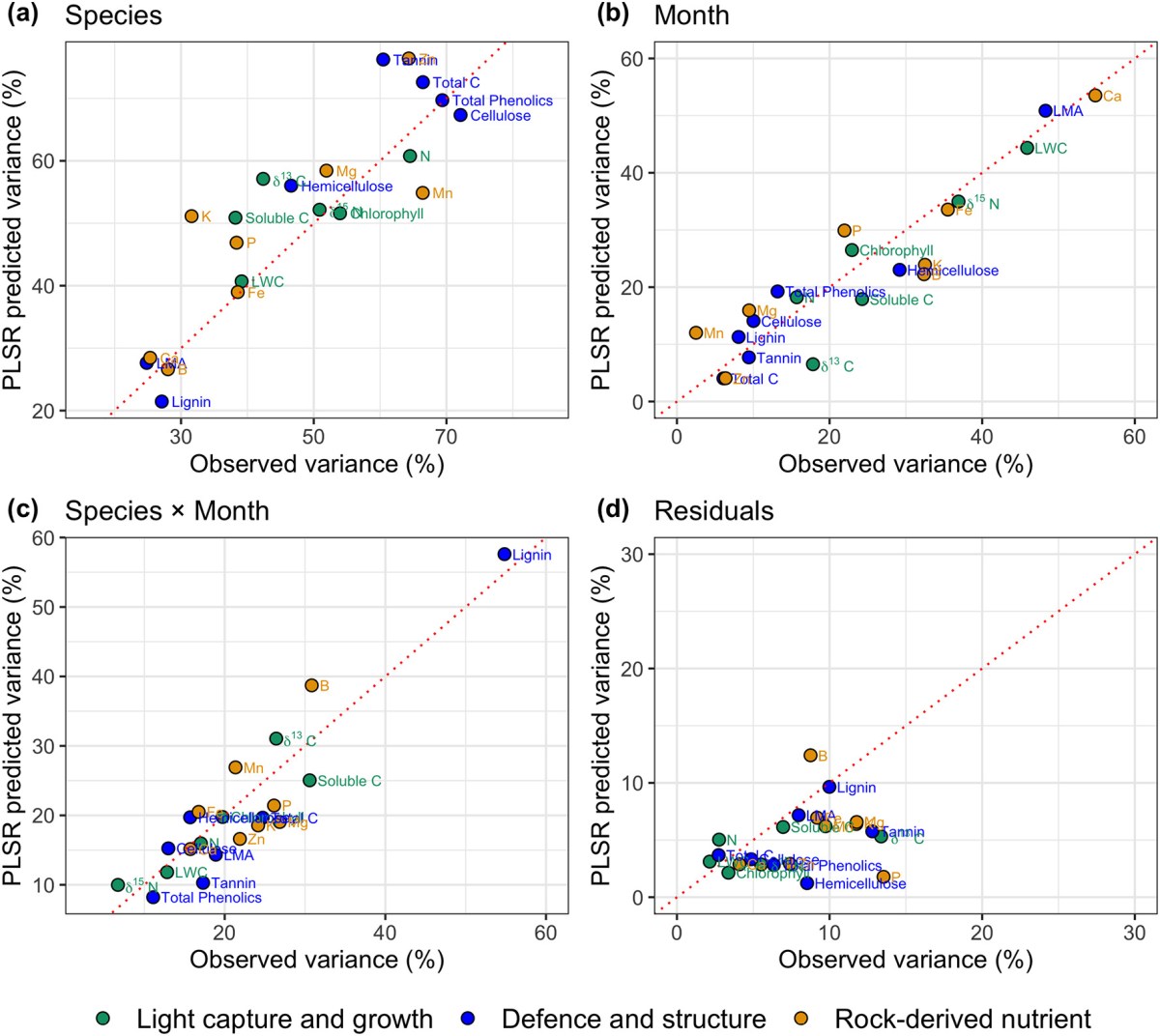
Imaging spectroscopy reveals the effects of topography and logging on the leaf chemistry of tropical forest canopy trees
In this study we show that logged tropical forests have reduced leaf nutrient concentrations compared with old-growth forests and this becomes more pronounced as forests recover in stature. Our findings suggest rock-derived nutrients, such as phosphorus, in short supply in tropical forests on old soils, are depleted by as much as 30% by logging. This…
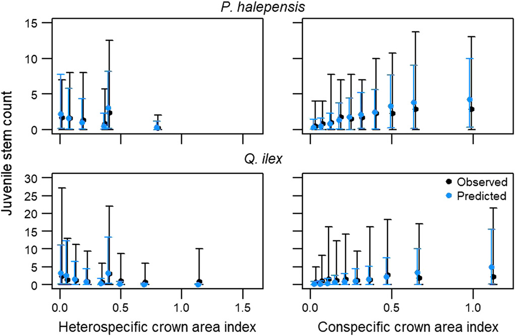
Capturing juvenile tree dynamics from count data using Approximate Bayesian Computation
The juvenile life stage is a crucial determinant of forest dynamics and a first indicator of changes to species’ ranges under climate change. However, paucity of detailed re‐measurement data of seedlings, saplings and small trees means that their demography is not well understood at large scales, and rarely represented in forest models in detail. In…
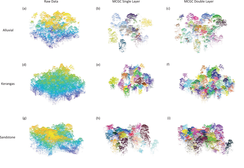
3D Segmentation of Trees Through a Flexible Multiclass Graph Cut Algorithm
Developing a robust algorithm for automatic individual tree crown (ITC) detection from airborne laser scanning (ALS) data sets is important for tracking the responses of trees to anthropogenic change. Such approaches allow the size, growth, and mortality of individual trees to be measured, enabling forest carbon stocks and dynamics to be tracked and understood. Many…
Seasonal drivers of understorey temperature buffering in temperate deciduous forests across Europe
Forest understorey microclimates are often buffered against extreme heat or cold, with important implications for the organisms living in these environments. We quantified seasonal effects of understorey microclimate predictors describing canopy structure, canopy composition and topography (i.e., local factors) and the forest patch size and distance to the coast (i.e., landscape factors). The local canopy…
Changes in leaf functional traits of rainforest canopy trees associated with an El Niño event in Borneo
El Niño events generate periods of relatively low precipitation, low cloud cover and high temperature over the rainforests of Southeast Asia, but their impact on tree physiology remains poorly understood. Here we use remote sensing and functional trait approaches – commonly used to understand plant acclimation to environmental fluctuations – to evaluate rainforest responses to…
Using image spectroscopy to study diversity in tropical forests
Tropical forests harbour remarkable density and diversity of woody plants, but how different processes interact to enable so many species to co-exist despite intense competition for resources is yet unresolved. Traditionally, tropical diversity has been studied by establishing field inventory plots, but this is difficult and labour-intensive task, which limits the area that can be…
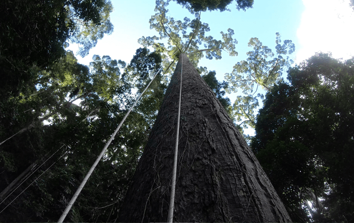
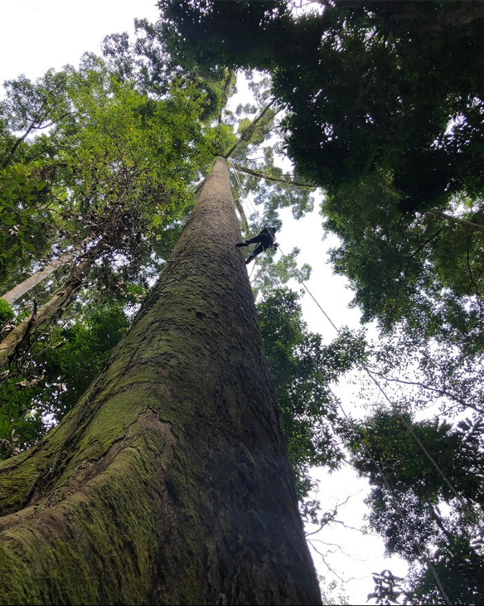
The world’s tallest tropical tree in three dimensions
Here we report the recent discovery of the world’s tallest tropical tree (Shorea faguetiana), possibly the world’s tallest angiosperm (flowering plant), located in the rainforests of Sabah, Malaysian Borneo. In addition, we provide a novel three-dimensional exploration of the dimensions of this remarkable tree and use these data to speculate on what drives the limits…
Mapping tree architecture with lasers
The complexity of tree architecture may be the reason we find trees relaxing but it is hard to account for in ecology. Along with our colleagues from UCL and Wageningen University, we mapped the range of tree architecture using terrestrial laser scanning data. This was done by scanning trees and forests from multiple locations, fitting…
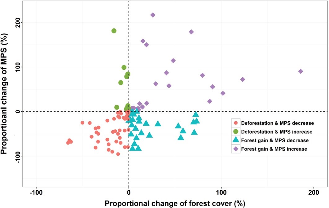
Forest gain doesn’t stop forest fragmentation in China
Most studies exploring habitat fragmentation effect on biodiversity were conducted at the local or regional level. These studies generally ignored background information (e.g. history, drivers and dynamics) of forest fragmentation which is critical for biodiversity conservation at large scales (e.g. national scale). Hence, these studies provided little practical implications for forest management in fragmented landscapes.…

Forests protect animals and plants against warming
We have quantified the temperature difference between sites within forests and outside, for the first time across the globe. Measurements occurred at 98 locations spread across five continents, in the tropics, temperate zone and northern boreal forests. The data show that the maximum temperature in forests is, on average across the globe, 4 degrees lower…

Indirect effects of habitat fragmentation on seed dispersers influence plant community structure
Traditional studies generally consider habitat fragmentation as a driver of downsizing of plant seeds due to the disappearance of large seed dispersing vertebrates. However, most of these studies focuses on old‐growth forests, and much less is known about influences of habitat fragmentation on seed size pattern in patches of regenerating forests. This pattern may differ…
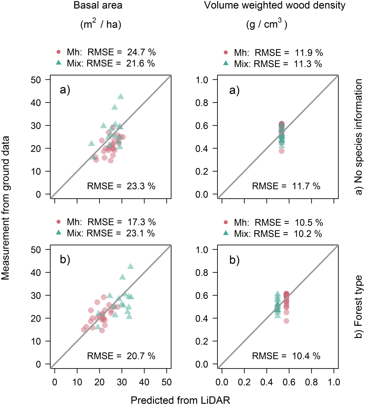
A critique of general allometry-inspired models for estimating forest carbon density from airborne LiDAR
There is currently much interest in developing general approaches for mapping forest aboveground carbon density using structural information contained in airborne LiDAR data. The most widely utilized model in tropical forests assumes that aboveground carbon density is a compound power function of top of canopy height (a metric easily derived from LiDAR), basal area and…
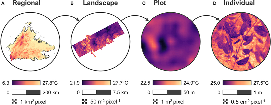
The microclimate mapping challenge
Organisms experience climate at a small scale, where the topography and the vegetation cause microclimates that vary greatly in space and time. The difference in temperature between north and south facing slopes of a mole hill on a hot summer’s day in Europe, for example, is comparable to the temperature difference between the Mediterranean and…
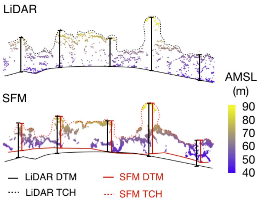
Canopy height mapping with drones
We have assessed the quality of three dimensional forest models produced from drone surveys, and conclude that concerns about their quality for canopy height and carbon measurement are unjustified. The rise of drones has been explosive. Rapid advances in technology and decreases in price have resulted in products that can be used off-the-shelf to survey…
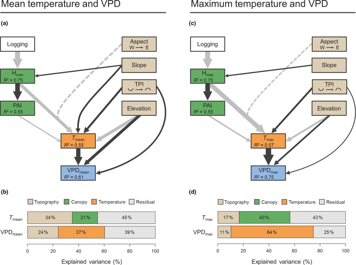
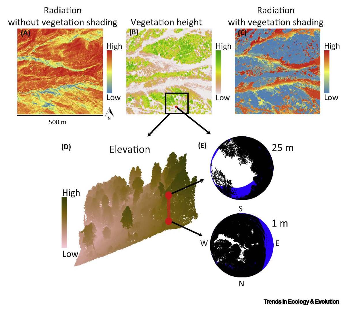
Canopy structure and topography jointly constrain the microclimate of human‐modified tropical landscapes
Local‐scale microclimatic conditions in forest understoreys play a key role in shaping the composition, diversity and function of these ecosystems. Consequently, understanding what drives variation in forest microclimate is critical to forecasting ecosystem responses to global change, particularly in the tropics where many species already operate close to their thermal limits and rapid land‐use transformation…
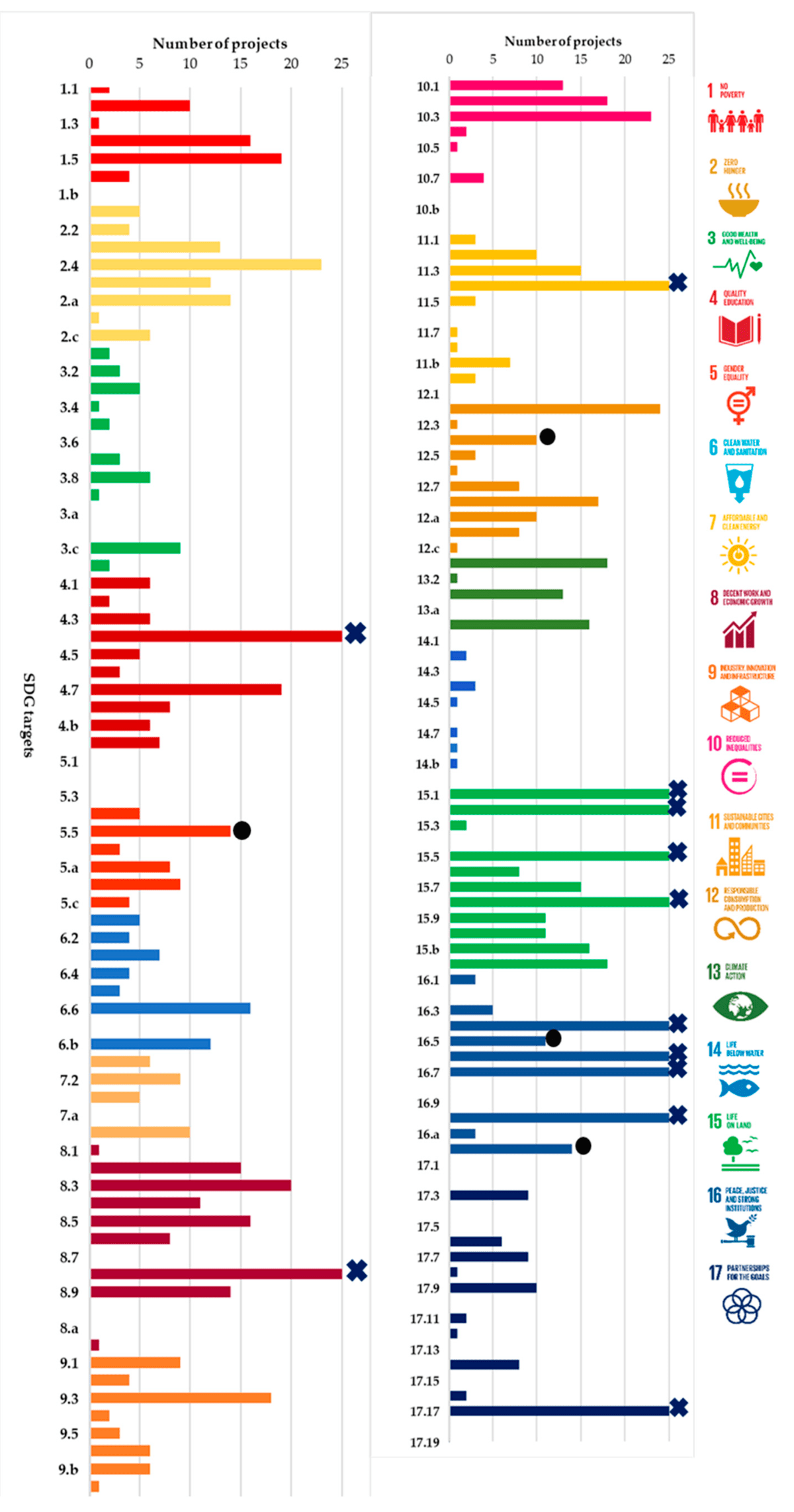
Assessing the Progress of REDD+ Projects towards the Sustainable Development Goals
Almost a decade since the establishment of Reducing Emissions from Deforestation and Degradation (REDD+), this study investigates the extent to which REDD+ projects are delivering on the promise of co-benefits and the elusive ‘triple-win’ for climate, biodiversity, and local communities. The Climate, Community and Biodiversity Alliance (CCB) is among several leading REDD+ certification standards that…

A simple approach to forest structure classification using airborne laser scanning that can be adopted across bioregions
Reliable assessment of forest structural types (FSTs) aids sustainable forest management. We developed a methodology for the identification of FSTs using airborne laser scanning (ALS), and demonstrate its generality by applying it to forests from Boreal, Mediterranean and Atlantic biogeographical regions. First, hierarchal clustering analysis (HCA) was applied and clusters (FSTs) were determined in coniferous…
Estimating aboveground carbon density and its uncertainty in Borneo’s structurally complex tropical forests using airborne laser scanning
Borneo contains some of the world’s most biodiverse and carbon-dense tropical forest, but this 750 000 km2 island has lost 62 % of its old-growth forests within the last 40 years. Efforts to protect and restore the remaining forests of Borneo hinge on recognizing the ecosystem services they provide, including their ability to store and sequester carbon. Airborne laser scanning…

Effect of Tree Phenology on LiDAR Measurement of Mediterranean Forest Structure
Retrieval of forest biophysical properties using airborne LiDAR is known to differ between leaf-on and leaf-off states of deciduous trees, but much less is understood about the within-season effects of leafing phenology. Here, we compare two LiDAR surveys separated by just six weeks in spring, in order to assess whether LiDAR variables were influenced by…
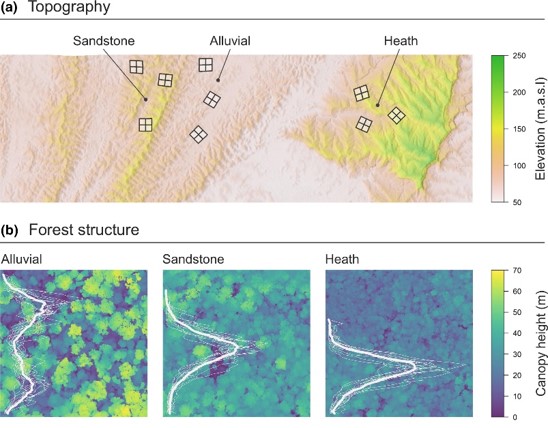
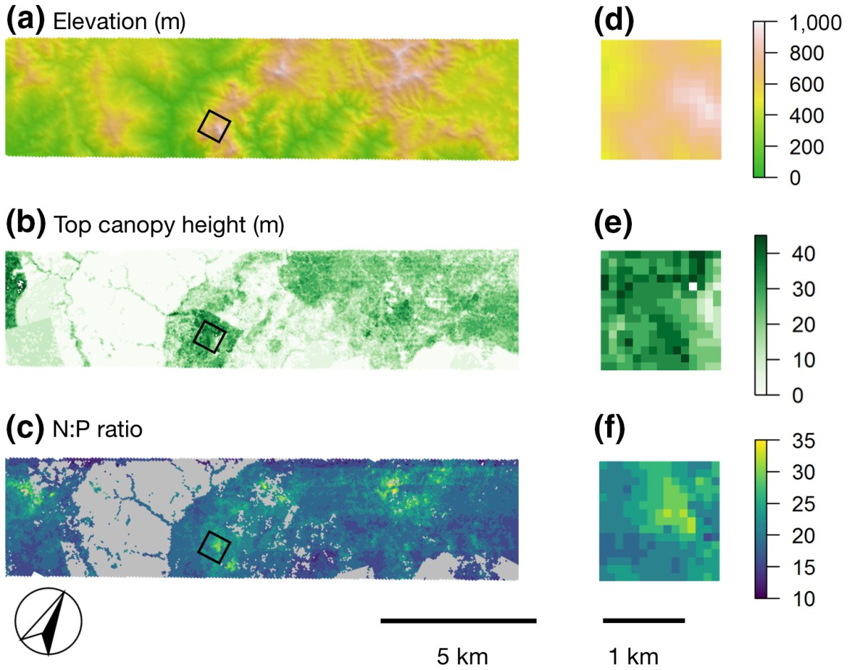
Topography shapes the structure, composition and function of tropical forest landscapes
Topography is a key driver of tropical forest structure and composition, as it constrains local nutrient and hydraulic conditions within which trees grow. Yet, we do not fully understand how changes in forest physiognomy driven by topography impact other emergent properties of forests, such as their aboveground carbon density (ACD). Working in Borneo – at…
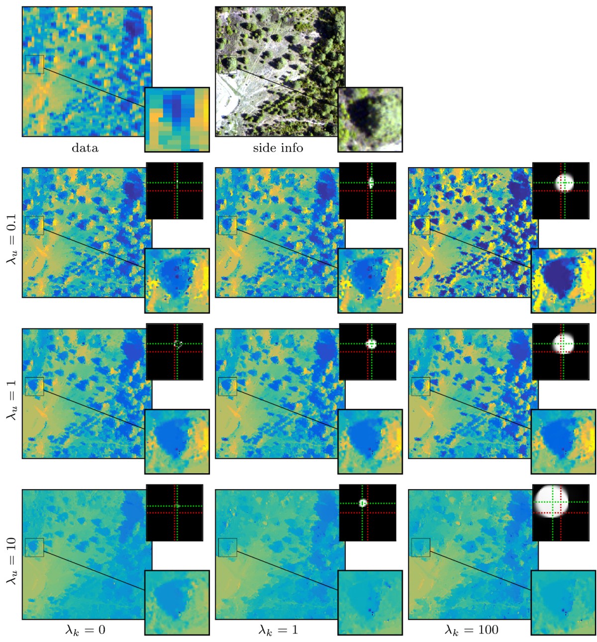
Blind image fusion for hyperspectral imaging with the directional total variation
Hyperspectral imaging is a cutting-edge type of remote sensing used for mapping vegetation properties, rock minerals and other materials. A major drawback of hyperspectral imaging devices is their intrinsic low spatial resolution. In this paper, we propose a method for increasing the spatial resolution of a hyperspectral image by fusing it with an image of…
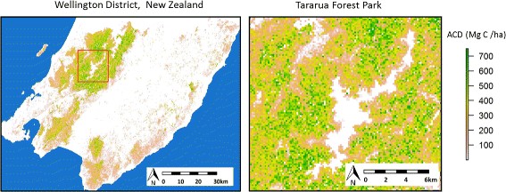
Airborne laser scanning of natural forests in New Zealand reveals the influences of wind on forest carbon
Forests are a key component of the global carbon cycle, and research is needed into the effects of human-driven and natural processes on their carbon pools. Airborne laser scanning (ALS) produces detailed 3D maps of forest canopy structure from which aboveground carbon density can be estimated. Working with a ALS dataset collected over the 8049-km2 Wellington…
Enhancing of accuracy assessment for forest above-ground biomass estimates obtained from remote sensing via hypothesis testing and overfitting evaluation
The evaluation of accuracy is essential for assuring the reliability of ecological models. Usually, the accuracy of above-ground biomass (AGB) predictions obtained from remote sensing is assessed by the mean differences (MD), the root mean squared differences (RMSD), and the coefficient of determination (R2) between observed and predicted values. In this article we propose a…
